My Story

Mission Statement
Every community has a different relationship with walking. Some neighborhoods encourage daily life on foot, while others make even short trips difficult without a car. The American Walkability Atlas is an independent research initiative dedicated to making walkability data more accessible, understandable, and useful for planners, researchers, public officials, and community members. Through interactive maps, GIS analysis, and planning research, the project explores how the built environment shapes pedestrian accessibility across the United States.
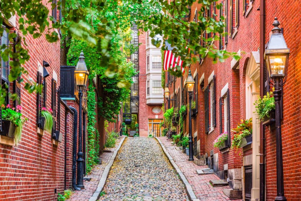
Acorn Street in Boston’s Beacon Hill neighborhood is one of the city’s most recognizable historic streets. Lined with Federal-style brick rowhouses, gas lamps, and cobblestone paving, it reflects the neighborhood’s early nineteenth-century urban form. Beyond its historic character, Beacon Hill remains highly walkable, with restaurants, shops, parks, transit, and civic destinations located within a short walking distance. The neighborhood demonstrates how compact, mixed-use development and a pedestrian-oriented street network can create a vibrant and enduring urban environment. Photo courtesy of (“Getting to Know Your Neighborhood,” n.d.).
About me
My interest in urban planning began with a simple question: How does the design of our streets, neighborhoods, and cities shape the way people live? That curiosity inspired me to pursue a career focused on understanding the built environment and how thoughtful planning can create healthier, more connected, and more livable communities.
I earned a Bachelor of Science in Urban and Regional Planning from Texas State University, where I built a strong foundation in land use planning, community development, zoning, and the planning processes that shape cities. Wanting to deepen my knowledge and technical skills, I continued my education by earning a Master of City and Regional Planning (MCRP) from the University of Texas at Arlington, specializing in walkability, Smart Growth, and New Urbanism.
During my graduate studies, I researched how urban form, land use mix, and transportation networks influence accessibility and quality of life. For my professional report, I analyzed walkability in Arlington, Texas using the U.S. Environmental Protection Agency’s National Walkability Index and Smart Location Database. This research strengthened my expertise in ArcGIS Pro, GIS-based spatial analysis, and data visualization while reinforcing my belief that the most effective planning decisions combine rigorous analysis with meaningful community needs.
That research ultimately became the foundation for the American Walkability Atlas, an ongoing project dedicated to exploring walkability and accessibility through GIS, interactive mapping, and planning research. My goal is to make complex planning data more understandable and accessible, helping planners, researchers, students, local governments, and community members better understand how the built environment influences everyday life.
At the heart of my work are three guiding principles:
- Walkability – Creating safe, connected, and inviting streets and neighborhoods that support health, equity, sustainability, and community interaction.
- Smart Growth – Encouraging compact, mixed-use, and transit-oriented development that balances growth with long-term environmental, economic, and social resilience.
- New Urbanism – Promoting human-scaled communities with vibrant public spaces, diverse transportation options, and neighborhoods where people can comfortably live, work, shop, and gather without relying solely on automobiles.
Today, my professional interests include walkability, urban design, land use planning, transportation planning, GIS, and spatial analysis. I enjoy using data and mapping to uncover patterns that help explain how communities function and where opportunities exist to improve accessibility and quality of life.
The American Walkability Atlas is an extension of these interests and values. Through this platform, I combine planning research with GIS technology to create interactive maps, data visualizations, and analytical resources that make complex planning concepts easier to understand. My vision is to bridge planning research and public understanding by providing transparent, evidence-based tools that support better planning decisions and contribute to creating more walkable, connected, and people-centered communities across the United States.
My Skills
Timeline of Walkability & Professional Experience
2016–2018 | Building the Foundation
Blinn College – Associate of Arts
Every journey begins somewhere. While earning my Associate of Arts degree at Blinn College, I built a strong academic foundation through coursework in the liberal arts, social sciences, and geography. During this time, I developed an appreciation for how geography shapes communities, cultures, and the relationships between people and places. These experiences strengthened my research, writing, and critical thinking skills while preparing me for advanced study at a four-year university.
Highlights
- Earned an Associate of Arts degree.
- Built strong analytical and communication skills.
- Developed an interest in geography and the relationship between people and places.
2018–2020 | Discovering Urban Planning
Texas State University
Bachelor of Science in Urban & Regional Planning (Cum Laude)
At Texas State University I formally entered the planning profession. My coursework introduced me to land use planning, transportation systems, zoning, urban design, environmental planning, and community development.
One of the most influential moments during this time was learning ArcGIS Pro. What began as a classroom tool quickly became the foundation of my professional interests. I became fascinated by using GIS to understand patterns in the built environment and communicate planning concepts through maps and spatial analysis.
Highlights
- Graduated Cum Laude with a B.S. in Urban & Regional Planning.
- Developed proficiency in ArcGIS Pro and GIS-based spatial analysis.
- Studied planning theory, Smart Growth, New Urbanism, and sustainable development.
- Began attending planning meetings and exploring communities through a planner’s perspective.
2021–2023 | Developing Professional Skills
FedEx Ground
Working in a fast-paced logistics environment strengthened my adaptability, teamwork, communication, and time-management skills. This experience reinforced the discipline and organizational abilities that continue to support my work as a planner.
Highlights
- Employee of the Month (July 2022).
- Developed strong communication, teamwork, and problem-solving skills.
2023–2025 | Graduate Research & Applied Planning
University of Texas at Arlington
Master of City & Regional Planning
Graduate school allowed me to combine planning theory with applied research. My studies focused on walkability, Smart Growth, New Urbanism, GIS, transportation planning, and sustainable community development.
Throughout the program I expanded my technical skills in ArcGIS Pro, Tableau, Adobe Creative Suite, Excel, and data visualization while completing multiple applied planning projects.
Professional Report
For my master’s professional report, I examined walkability around the Pioneer Parkway–Arkansas Lane–Cooper Street–Matlock Road intersection in Arlington, Texas. Using the EPA’s National Walkability Index and Smart Location Database, I evaluated how urban form, transit accessibility, land use diversity, and intersection density influence walkability.
This research ultimately became the foundation for the American Walkability Atlas.
Highlights
- Applied GIS-based spatial analysis.
- Conducted regression analysis using EPA datasets.
- Connected findings to Jane Jacobs, Smart Growth, New Urbanism, and the 15-Minute City.
- Developed professional reports and cartographic products.
2024 | Capital Improvement Planning
City of River Oaks Capstone Project
Working directly with the City of River Oaks, our graduate team developed a Capital Improvement Plan designed to prioritize future infrastructure investments.
The project included facility assessments, community engagement, and a survey completed by 189 residents. We evaluated streets, drainage systems, utilities, municipal facilities, and emergency services before presenting recommendations to city officials.
Highlights
- Infrastructure planning.
- Community engagement.
- Public survey design and analysis.
- Capital Improvement Planning.
- Municipal collaboration.
2024–Present | Professional Development
Planning extends beyond the classroom. During this period I continued building my professional network and expanding my understanding of local government.
Professional Involvement
- American Planning Association (APA) member.
- Pi Alpha Alpha Honor Society.
- Student Planning Association.
- Mansfield Muni-Versity graduate.
- Certificate in Location Analysis.
- Regular attendee of planning and zoning meetings in Mansfield and San Marcos.
2025–Present | American Walkability Atlas
The American Walkability Atlas represents the natural evolution of my graduate research.
After discovering the limitations of static planning maps, I taught myself WordPress, Elementor, ArcGIS Online, QGIS, GitHub, and interactive web mapping to create a publicly accessible platform exploring walkability across the United States.
Today the Atlas includes:
- Interactive walkability maps covering thousands of municipalities.
- Metropolitan and neighborhood-level analyses.
- Service Area Analysis.
- Walkability methodology and research.
- GIS-based visualizations of the built environment.
- Educational resources for planners, researchers, students, and the public.
2025-Present: Looking Ahead
My career is only beginning.
As I continue working in the planning profession, I also plan to expand the American Walkability Atlas through new GIS analyses, service area modeling, accessibility research, and additional planning resources.
My long-term goal is to bridge planning research and public understanding by developing transparent, data-driven tools that help planners, local governments, and communities create more walkable, connected, and resilient places.
References
- Getting to Know Your Neighborhood: Beacon Hill. (n.d.). Boston University. Retrieved August 3, 2026, from https://www.bu.edu/articles/2025/getting-to-know-your-neighborhood-beacon-hill/